What is Geographic Information Systems (GIS), and does it have to do with digital marketing and SEO? This is one of the most common questions anyone (and everyone) asks when they first hear this phrase. While it’s not a common acronym, it is something people interact with nearly every day without realizing it, and it’s something we use for our client’s digital marketing strategies at Hennessey Digital. Even though it might not sound like it has anything to do with digital marketing and SEO, it actually plays quite an important role.
Let’s dive in with some history to see how we got to where we are today and why GIS so profoundly impacts the digital space.
What is GIS?
The key to GIS is geography. GIS is all about the use of any location data or any data that is related to the “where” of things. The more data that’s available, the better GIS can work.
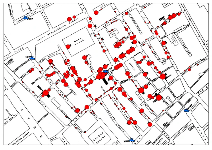
One of the first instances in the history of GIS (long before computers) is the famous map created by John Snow, a doctor and epidemiologist from London in 1854. At the time, he was seeing a high number of patients suffering from cholera. Neither he nor anybody else could figure out what was causing this outbreak, so Snow started to mark on a map where his sick patients lived and marked the location of water pumps in the area. Quickly he began to recognize a pattern that there were more sick patients concentrated around one specific water pump. He reported his findings and the identified water pump was determined to be contaminated – and therefore, shut down. The number of cholera cases began to decline thanks to his work, and his study has now become one of the go-to examples of early GIS in practice.
How does GIS work?
Modern GIS didn’t really take off until the 1990s with the development of computer technology and the internet for better data management, processing, and sharing. But the logic and process are still quite similar to what it was decades prior.
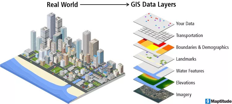
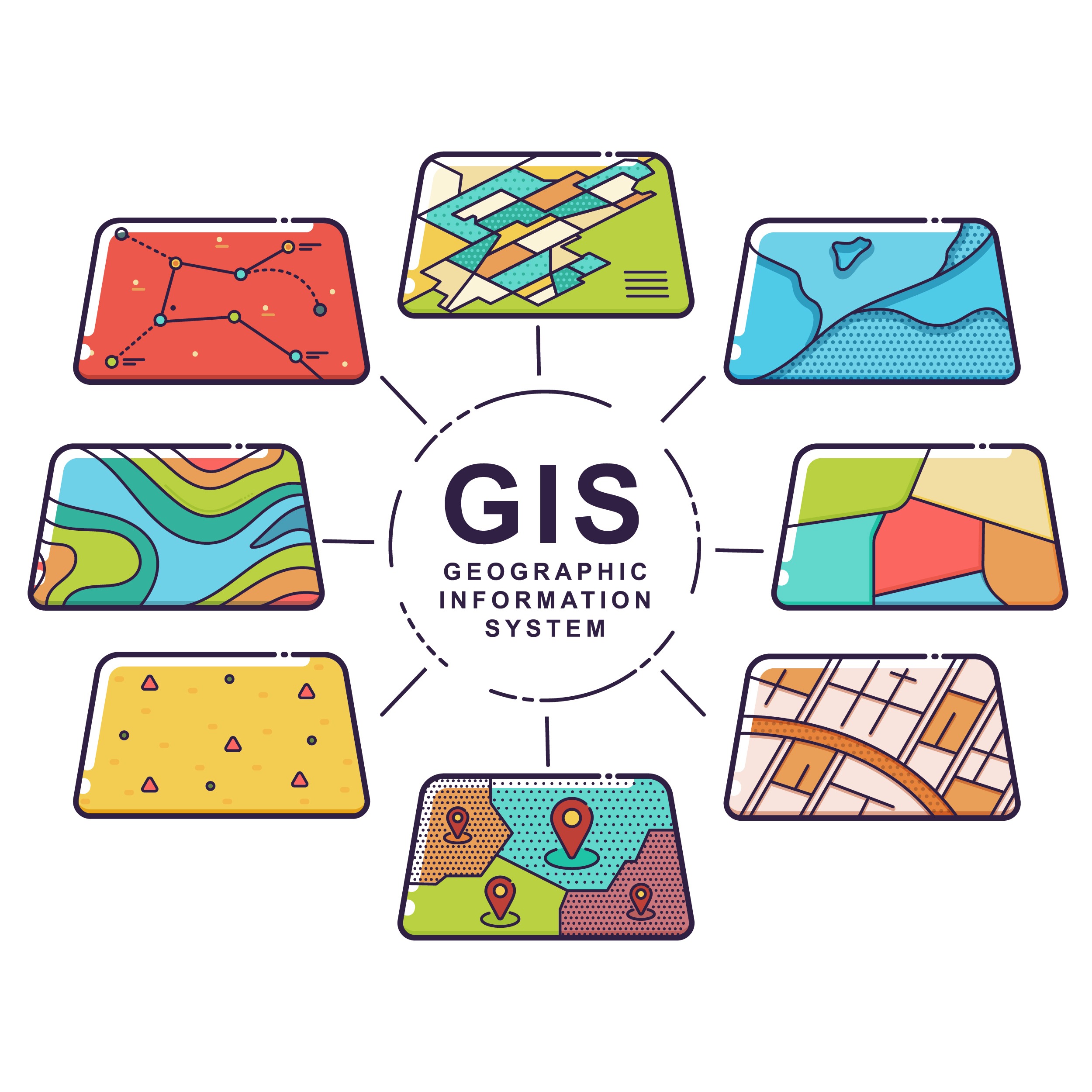
The key thing in GIS is data layering as seen in the diagram above. GIS is able to take data and create it into individual layers that can then stack on top of each other to create unique visualizations and identify patterns that could go unnoticed. The unique layering and data patterns working alongside current digital marketing and SEO strategies and techniques can create better planning and new decision-making processes.
To begin any GIS project we need data. Unlike data in a chart, data for GIS requires a reference to a location. In GIS, there are three main data types and all of them can either be used alone or as a combination:
Polygon data – This is like drawing country or state boundary lines. But polygons aren’t just limited to political boundaries or pre-drawn data available. With the use of different GIS tools, custom polygon shapes can be made to fit an exact area you’re interested in knowing more about.
Line data – This is like roads or rivers. And just like polygons, lines don’t just have to be pre-made. Custom lines can be created to fit a project.
Point data – Point data is the most-used data type in GIS, and can either be single instance or distinct data points. This can be addresses for buildings or different points of interest. Point data can be downloaded from different reputable sources, or created and recorded in a table. As long as each row in the table has an associated latitude and longitude or an address, then it can be converted in a GIS program and placed on a map for easier data visualization.
Once you determine the type of data you want to use, it can be created, downloaded, or imported into GIS software to be manipulated and analyzed. The most common GIS programs used are the industry standard ArcGIS Pro developed by ESRI, or an open-source, free alternative is QGIS. Both softwares have pros and cons, but foundationally they both are able to do a high-level analysis of geographic data.
GIS softwares work with unique file types that are used to combine table data and information that is relayed to the software on how and where to draw data. Once all this data is put into the software, the fun part of the analysis begins. In GIS there are many different geospatial tools used that can be used in infinite combinations that can accomplish the goal.
Once all the data is analyzed, it can be shared as a static map using various cartographic methods or brought into even more software available to create interactive maps, which is becoming more and more popular.
Where is GIS used today?
In the early days of modern GIS, it was primarily developed for environmental research to allow scientists and geographers to get a better bird’s eye view of their data and research sites. Today, GIS has stretched long beyond the confines of environmental science to the point where nearly every industry does, could, or should be using GIS.
For example, GIS is used quite a bit in the real estate sector when creating built-in maps for real estate websites to allow customers to view properties easily. Realtors also use it internally to get a visual of real estate trends that show the appreciation and depreciation of an area.
Another great example of GIS in action is with logistics companies. Companies that deliver mail or transport goods heavily rely on GIS to develop the most efficient routes for their drivers or the best routes to transport goods along. This process allows for cost-saving planning before the trucks even hit the roads.
A newer trend is using data forecasting with geographic data. As time has gone on, many GIS data sources have been able to store longitudinal, historical data. The availability of this data has allowed the opportunity for data science and GIS to blend together to plan for future events. A current example of this is mapping coastal flooding and being able to plan and prepare for where floods are more likely to occur. This data forecasting also allows aid agencies to know where to send resources in the event of natural disasters.
These are broad-term examples, but the most specific example that perfectly encapsulates GIS in digital marketing and one that most people are familiar with is Google Maps.
GIS and Google Maps
Google Maps mixes every type of GIS data together, from generating red polygons when you click on a city’s name to see where Google draws a city’s boundaries, to using line data for navigation of your route. Google Business Profiles act as point data in the map showing you where businesses are located and includes information on a specific business from phone number to hours of operation and reviews.
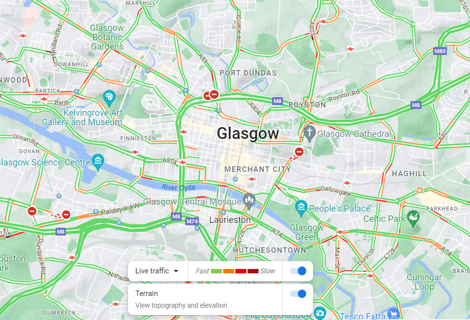
In fact, Google Maps also has a sort of “behind the scenes” look. If you go to Google Maps, you can switch to different layers and one of them is the traffic layer. You can see the roads and the traffic overlaid on top. When you get directions from Google it takes several different factors into account, including road laws like speed limit, road type (residential road vs highway), flow of traffic, and actively pulls data on traffic patterns. It may navigate you around heavily trafficked roads that slow you down or direct you around construction sites.
What is the relationship between digital marketing and GIS?
GIS can provide a wealth of information that can go unknown or unnoticed unless you knew it was available.
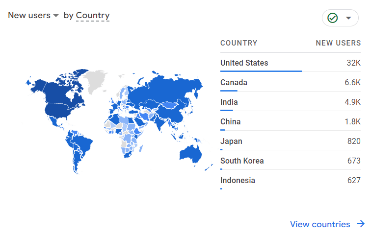
Google Analytics has a very basic form of GIS visualization built into it. You can look at a location overview to see where your audience is coming from, but Google is limited in what data it can pull and collect. It heavily relies on tracking the user based on their IP address and their site activity, but that is all the information Google Analytics can get. This is where GIS comes in to fill in the gaps and build out even more information on your potential user audience.
GIS can be used to provide a much more educated strategy for SEO and digital marketing plans. For example, say you want your website to reach a specific target audience based on demographics. The United States Census Bureau collects this information every 5 and 10 years and makes that data publicly available. Using GIS, you can download this data and work with it to overlay all your different target audience characteristics to figure out where that ideal audience is. Then you can use that information to make more informed decisions in your SEO strategy to reach your target audience faster than before.
GIS can help reduce the chance of creating an SEO strategy that does not reach your intended audience because the audience is either limited or not where you thought it would be.
How we use GIS here at Hennessey Digital
Local SEO strategies for law firms
One of the most common uses for GIS we use here at Hennessey Digital for our law firm SEO strategy is collecting car crash data that different state agencies provide to the public. Almost every state in the country collects information on how many car crashes happen annually in their state. Some states go further to include more granular data on where the accidents occur such as counties, cities, or even location data on where accidents occur.
This available data helps to identify areas with high numbers of car crashes based on different criteria, or to provide a bird’s eye view of the data trends for the state. We combine all of this data with our unique analysis methodology to help create a more targeted SEO strategy that can quickly meet your audience.
Seasonality
Historical data is valuable in recognizing seasonal patterns of different phenomena. Knowing the seasonal patterns of an area provides answers on why data collected in Google Analytics is either doing better or worse compared to previous periods. It can also predict when a website may see more traffic for specific pages because more people in that area could be doing web searches using those keywords. It can even be used to prepare new website content to cater to seasonal trends rather than miss the peak window of time for a topic.
New business locations for clients
Determining a new business location requires taking several factors into consideration, especially when it comes to SEO. Savvy businesses want to be strategically positioned in a good SEO market while also being in a location with people needing their services who can be directed to their site. GIS is able to take all these factors into consideration and create a unique analysis and map that reflect the potential best locations for new business locations. We take into account data such as demographics to find your target audience, historical data trends, and potential up-and-coming trends to ensure better success for a new location.
The Future Outlook of GIS
GIS is and will continue to be a growing industry as more industries begin to adopt its capabilities. And using GIS in digital marketing and SEO is no exception to that growth. Every day, new techniques and tools are being developed to continue to push the boundaries of what GIS is capable of doing. It is becoming more commonplace to use GIS and the popular coding language Python together to create custom tools for unique projects. Python’s popularity primarily in data science and analysis makes it complementary to GIS’s analysis abilities. It even helps develop automation processes and integrate data science methods to give more insights into data.
As the blended field of GIS and digital marketing is just beginning, so are the ideas that come with it. Creative uses for data and analytics can create a well-strategized website that can reach its target audience faster than before.

